Dutch space instrument SPEXone produces world map of aerosols
7 februari 2025
News
PACE climate satellite celebrates first year in space on February 8
On February 8th 2024, NASA launched its PACE climate satellite with onboard the Dutch aerosol instrument SPEXone. A full year of observations now yields a world map of aerosols. It shows the distribution of fine and coarse aerosols and of particles that reflect or absorb sunlight. The latter respectively have cooling and warming effects on the climate. SPEXone was built by SRON and Airbus Netherlands, with support from TNO.
Aerosols are small particles in the atmosphere such as soot, ash and desert dust, also called particulate matter. They have a net cooling effect on the climate, but to what extent is unclear. The estimate ranges from 0.2 to as much as 0.9 degrees dampening influence on global warming. Aerosols affect the climate both directly via reflection and absorption of sunlight, and indirectly by acting as condensation cores for cloud formation. For example the lack of low-level cloud cover is one of the causes of the record-warm year 2024.
World map
After a year in space, SRON’s SPEXone team has now produced three global aerosol maps. The first shows the distribution of aerosols across Earth’s atmosphere. The second map shows the amount of fine aerosols relative to the total number of both fine and coarse aerosols. Here we see that fine particles mostly occur above areas with much traffic and industry such as India and regions with many fires such as central Africa and Siberia. Desert dust and sea salt, on the other hand, are coarser particulate matter, corresponding to the blue pixels on the locations of deserts and oceans. The third map shows the amount of reflecting aerosols—with a cooling effect—relative to the total number of aerosols at that location. This gives an overall picture of the direct effect of particulate matter on the climate.
Climate models
‘The next step is to play around with variables in climate models until they produce this same image,’ says Otto Hasekamp (SRON), leader of the SPEXone team. ‘Then you know you have the right properties of aerosols in the models. And then we know the direct damping influence they have on global warming, the sum of reflection and absorption.’
Clouds
Then what remains is the indirect influence of aerosols on the climate, through cloud formation. Clouds form when water vapour attaches to particles in the air, forming droplets. With more aerosols, the water vapour is distributed over more condensation cores, so you get smaller droplets. But the extent to which this applies is unknown. Hasekamp: ‘This is another aspect that we will be working on with climate models in the coming year. The global map of fine and coarse aerosols provides us with the input for this, because the size of an aerosol particle determines whether it is suitable to form a cloud droplet.’
Dutch invention
Eppo Bruins, the Dutch Minister of Education, Culture and Science, says: ‘I am impressed by the research SRON is conducting with this Dutch invention. The atmosphere is a complex system and climate has a major impact on our lives. We still have insufficient knowledge about the exact functioning of the atmosphere and climate change. With this research, climate models can be strongly improved, so the knowledge can be used immediately.’
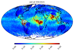
Figure 1: World map of the amount of aerosol, shown as the Aerosol Optical Depth. The map shows the average value for each location on earth for the period March to December 2024.
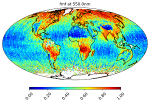
Figure 2: World map of fine aerosols relative to total aerosols, including both fine and coarse. Deserts and oceans are clearly shown in blue because desert dust and sea salt are coarser aerosols. Regions with a lot of industry and traffic (e.g. India) and areas with a lot of fires (e.g. central Africa and Siberia) are red, because those processes produce finer particles. The map shows the average value for each location on earth for the period March to December 2024.
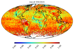
Figure 3: World map of the amount of reflective aerosols relative to the total amount of aerosols, including reflecting and absorbing. Reflecting aerosols (red) have a cooling effect. Absorbing aerosols (blue) have a warming effect. Smoke particles from forest fires absorb sunlight, which can be clearly seen in California, northern Siberia and central Africa. The map shows the average value for each location on earth for the period March to December 2024.
The world maps will soon be published in Geophysical Research Letters. SPEXone is developed by a Dutch consortium consisting of SRON and Airbus Netherlands, supported by TNO. SRON and are responsible for the design, assembly and testing of the instrument. The scientific leadership is in the hands of SRON. SPEXone is a public-private initiative made possible by the NSO with resources made available by OCW and by SRON/NWO-I and supported by private investments from Airbus Netherlands.
7 februari 2025
News
Duo of Satellites Detect Large Methane Emission from Ethiopian Volcano
21 januari 2025
News
Annual carbon monoxide emissions measured from Europe’s 21 largest steel plants

2 december 2024
News