PACE climate satellite releases first images
12 april 2024
News
NASA’s klimaatsatelliet PACE, met aan boord het Nederlandse instrument SPEXone, heeft de mijlpaal van First Light bereikt. Daarmee heeft de wereld nu toegang tot satellietbeelden die type en grootte van fijnstofdeeltjes onderscheiden. SPEXone meet ook de mate waarin aerosolen zonlicht absorberen en reflecteren. Hiermee kunnen wetenschappers de onzekerheden in klimaatmodellen verkleinen. SPEXone is gebouwd door SRON en Airbus Netherlands B.V., met ondersteuning van TNO.
Sinds de lancering op 8 februari 2024 vanaf NASA’s Kennedy Space Center in Florida is PACE zorgvuldig aangezet om te checken of alle instrumenten de heftige schokken en blootstelling aan de ruimte goed hebben doorstaan. Dat resulteert nu in de eerste wetenschappelijke afbeeldingen—First Light. ‘Uiteindelijk gaan heel veel van dit soort metingen optellen tot een compleet beeld van aerosolen in de atmosfeer,’ zegt Otto Hasekamp (SRON), hoofdonderzoeker van SPEXone. ‘We brengen in kaart hoeveel van welke soort fijnstof er is, en gaan die informatie combineren met klimaatmodellen om te onderzoeken wat hun bijdrage is aan de wereldwijde temperatuur. Dan weten we beter in welke mate fijnstof de opwarming door broeikasgassen maskeert.’
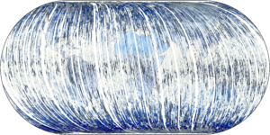
Figure 1: World map in polarized light, compiled from 100-km wide strips that are drawn by SPEXone in its orbit around the Earth. Credit: SRON
‘SPEXone works exactly as we conceived and designed and it behaves just like in the latest tests on the ground,’ says Marc Oort, systems architect at Airbus. ‘SPEXone is ready for its important task.’
Figure 1 shows the world as seen from behind polaroid sunglasses, compiled from SPEXone’s hundreds of orbits around the Earth. The instrument draws a 100-km wide strip across the Earth, like a push broom, in the south-north direction. Different backgrounds such as ocean and land polarize sunlight in their own way, making them look different. For example, land is often blue because only the scattered light in the sky above is polarized.

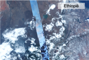
Figure 2: SPEXone casts its 100-km wide field of view over Japan (left) and Ethiopia (right). The instrument measures to what extent sunlight is polarized for multiple colors, from five different viewing angles. Credit: SRON
Figure 2 contains a SPEXone trajectory over Japan and Ethiopia. The rest of the picture was created by the OCI instrument, also onboard PACE. Clouds are black because they don’t polarize any color. Aerosols reveal themselves by polarizing all colors of sunlight. After analyzing this polarization data, the SPEXone team maps the properties of the aerosols, as shown in Figure 3.

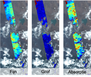
Figure 3: The conclusions from the polarization measurements above Japan (left) and Ethiopia (right). The panels show the amount of fine particles, coarse particles and the amount of absorption. Credit: SRON
Figure 3 shows the properties of aerosols over Japan (left) and Ethiopia (right). Both consist mainly of fine particles. Both left panels show many red and yellow spots, while the middle panels are largely blue. In the right panel we see that the aerosols above Ethiopia absorb lots of sunlight; it has the signature of smoke from the combustion of biomass. Above Japan we see a lot of aerosols around Tokyo blown southwards. The right panel shows the signature of a mix of urban pollution and natural aerosols such as sea spray.
Jeroen Rietjens (SRON) was working in the control room at NASA’s Goddard Space Flight Center while the first data came in. ‘After we entered the command to turn on SPEXone, it was a huge relief to see our instrument in good health. Two weeks later we were even happier when we took the first camera images and managed to create aerosol maps. It was the culmination of years of hard work of the entire team.’
SPEXone was developed by a Dutch consortium consisting of SRON and Airbus Netherlands B.V., with support from TNO. SRON and Airbus are responsible for the design, assembly and testing of the instrument. The scientific leadership is in the hands of SRON. SPEXone is a public-private initiative made possible by NSO with resources made available by OCW and by SRON/NWO-I and supported by private investments from Airbus Netherlands B.V.
0 News articles Found
There are no articles found that are related to this article