Methane: a driver of current climate change
SRON’s role in monitoring methane
Despite its seemingly low concentration in the atmosphere of less than 0.0002%, methane (CH4) is the second most important anthropogenic greenhouse gas, due to its high global warming potential. Over a period of a hundred years, methane is about thirty times more powerful than CO2. The 2021 IPCC report indicates a 0.28oC contribution to the total global warming of 1.1oC since pre-industrial times. Together with other Dutch partners, SRON has developed key technology for the TROPOMI instrument on the Copernicus Sentinel-5 Precursor mission. SRON is responsible for the CH4 data product and uses this data to estimate methane emissions worldwide. We specifically target super-emitters, for example some landfills or fossil fuel facilities. These have the potential to be the low-hanging fruit in efforts to mitigate global warming. SRON also develops the targeted TANGO mission to observe localized methane emission sources, together with our Dutch partners: ISIS Space, TNO, and KNMI.
-
projects
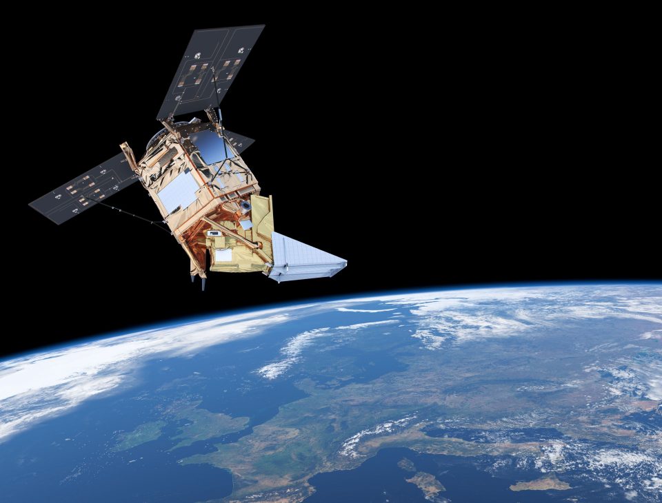
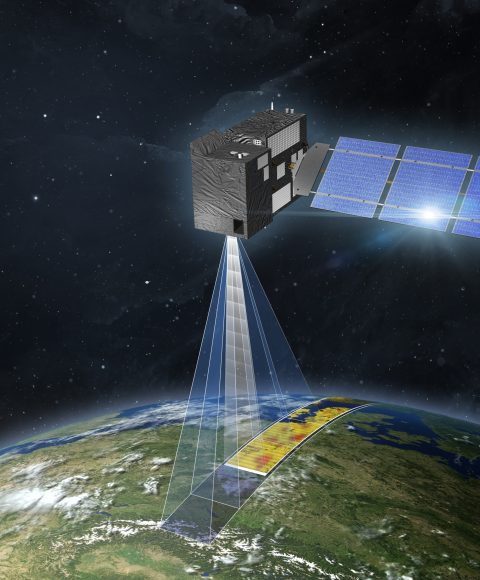
TROPOMI
The Dutch Tropospheric Monitoring Instrument (TROPOMI) is flying onboard the Copernicus Sentinel-5p mission, launched in 2017. Every day it scans the entire globe for e.g. methane and carbon monoxide concentrations at city-scale level.
-
projects
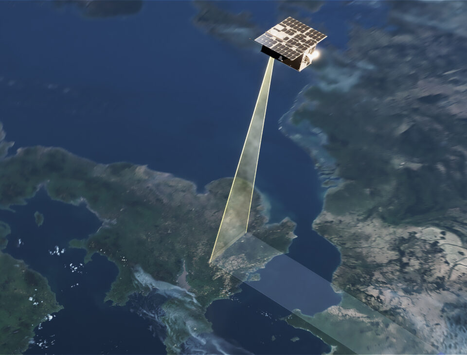
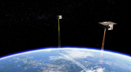
TANGO
The Twin Anthropogenic Greenhouse Gas Observers (TANGO) comprises two cubesats: TANGO-Carbon and TANGO-Nitro. It is a candidate mission of ESA’s SCOUT program to be launched in 2026.
-
projects
Impact Plan ML
We use machine learning techniques to detect methane plumes in satellite data. The first project focused on detection of methane plumes in TROPOMI data.
-
projects
IMEO MARS
The United Nations International Methane Emissions Observatory (IMEO) is setting up a Methane Alert Response System (MARS) to support governments and businesses to reduce their methane emissions as promised under the Methane Pledge.

-
projects
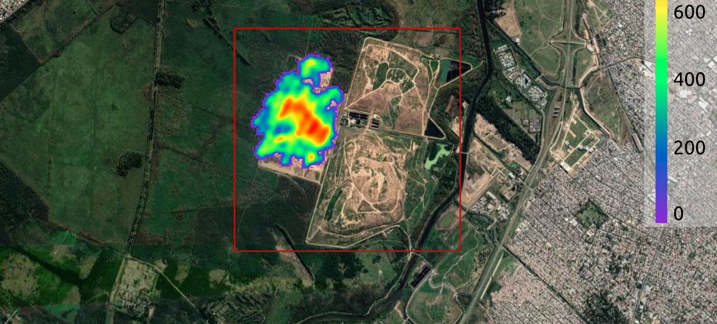
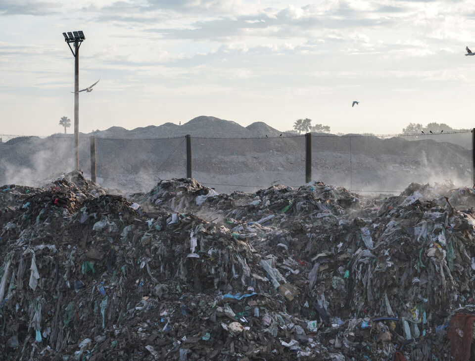
Targeting Waste Emissions Observed from Space
Emissions from landfills are responsible for about 11% of global human-made methane emissions. We have recently demonstrated we can detect and quantify large landfill methane emissions from space by using a combination of satellites.
-
projects
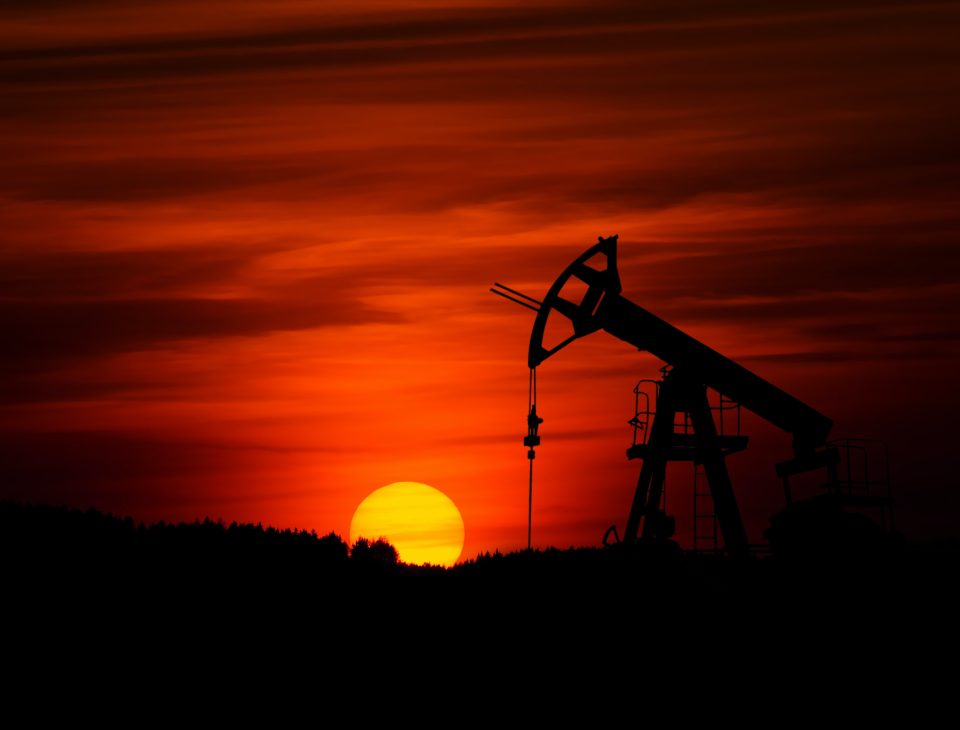
CCAC Methane Studies
CCAC Methane Studies is a project to estimate methane emissions from oil & gas fields using TROPOMI (and other) satellite data.


Recent methane news
News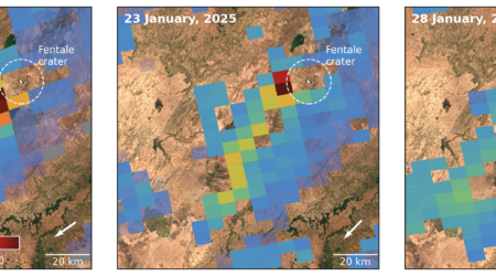
7 februari 2025
News
Duo of Satellites Detect Large Methane Emission from Ethiopian Volcano
2 december 2024
News
White paper: NL-US collaboration in climate research from space

19 september 2024
News
Pixels TROPOMI methane detector almost completely intact
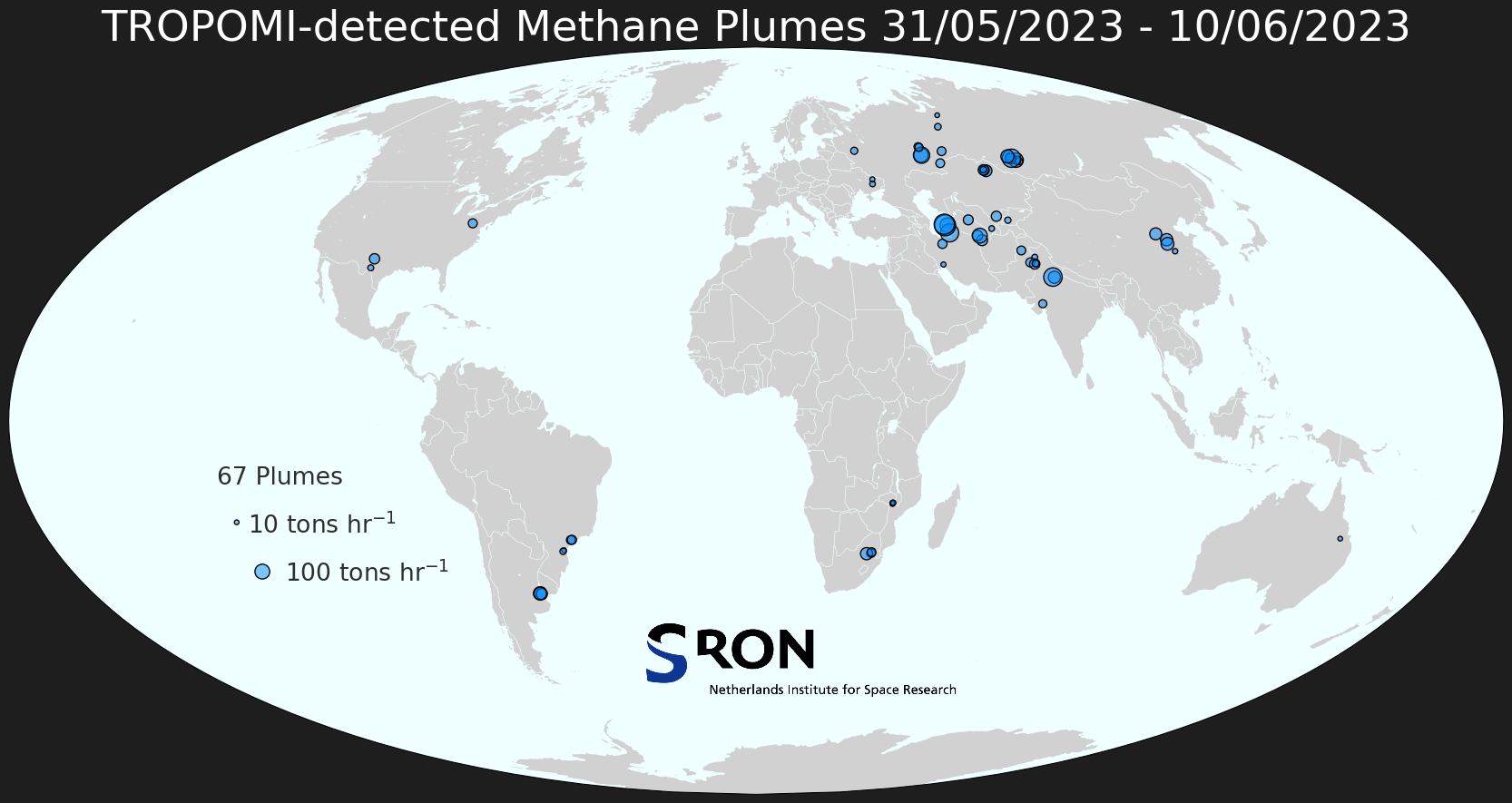
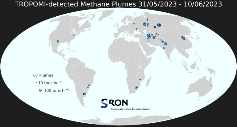
Methane Plume Map
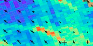
TropomiTROPOMI aboard Sentinel-5p can be used to detect large methane emission plumes everywhere around the world. These plumes are automatically detected using the machine-learning setup described in Schuit et al. (2023). The weekly world maps show approximate source locations based on single TROPOMI plumes as well as initial source rate estimates based on an automated mass balance method.
Interactive TROPOMI carbon monoxide / methane map
Methane Publications
1 februari 2025
Aerosols and Clouds
Satellite monitoring of annual US landfill methane emissions and trends
We use satellite observations of atmospheric methane from the TROPOMI instrument to estimate total annual methane emissions for 2019–2023 from four large Southeast US landfills with gas collection and control systems. The emissions are on average 6× higher than the values reported by the landfills to the US Greenhouse Gas Reporting Program (GHGRP) which are used by the US Environmental Protection Agency for its national Greenhouse Gas Inventory (GHGI). We find increasing emissions over the 2019–2023 period whereas the GHGRP reports a decrease. The GHGRP requires gas-collecting landfills to estimate their annual emissions either with a recovery-first model (estimating emissions as a function of methane recovered) or a generation-first model (estimating emissions from a first-order decay applied to waste-in-place). All four landfills choose to use the recovery-first model, which yields emissions that are one-quarter of those from the generation-first model and decreasing over 2019–2023, in contrast with the TROPOMI observations. Our TROPOMI estimates for two of the landfills agree with the generation-first model, with increasing emissions over 2019–2023 due to increasing waste-in-place or decreasing methane recovery, and are still higher than the generation-first model for the other two landfills. Further examination of the GHGRP emissions from all reporting landfills in the US shows that the 19% decrease in landfill emissions reported by the GHGI over 2005–2022 reflects an increasing preference for the recovery-first model by the reporting landfills, rather than an actual emission decrease. The generation-first model would imply an increase in landfill emissions over 2013–2022, and this is more consistent with atmospheric observations.
1 januari 2025
Aerosols and Clouds
Enhanced CH4 emissions from global wildfires likely due to undetected small fires
Monitoring methane (CH4) emissions from terrestrial ecosystems is essential for assessing the relative contributions of natural and anthropogenic factors leading to climate change and shaping global climate goals. Fires are a significant source of atmospheric CH4, with the increasing frequency of megafires amplifying their impact. Global fire emissions exhibit large spatiotemporal variations, making the magnitude and dynamics difficult to characterize accurately. In this study, we reconstruct global fire CH4 emissions by integrating satellite carbon monoxide (CO)-based atmospheric inversion with well-constrained fire CH4 to CO emission ratio maps. Here we show that global fire CH4 emissions averaged 24.0 (17.7–30.4) Tg yr‑1 from 2003 to 2020, approximately 27% higher (equivalent to 5.1 Tg yr‑1) than average estimates from four widely used fire emission models. This discrepancy likely stems from undetected small fires and underrepresented emission intensities in coarse-resolution data. Our study highlights the value of atmospheric inversion based on fire tracers like CO to track fire-carbon-climate feedback.
1 december 2024
Aerosols and Clouds
Integrating Satellite Observations and Hydrological Models to Unravel Large TROPOMI Methane Emissions in South Sudan Wetlands
This study presents a comprehensive investigation of Methane (CH4) emissions in the wetlands of South Sudan, employing an integrated approach that combines TROPOMI satellite data, river altimetry, and hydrological model outputs. TROPOMI data show a strong increase in CH4 concentrations over the Sudd wetlands from 2018 to 2022. We quantify CH4 emissions using these data. We find a twofold emission increase from 2018 to 2019 (9.2 ± 2.4 Tg yr‑1) to 2020 to 2022 (16.3 ± 3.3 Tg yr‑1). River altimetry data analysis elucidates the interconnected dynamics of river systems and CH4 emissions. We identify correlations and temporal alignments across South Sudan wetlands catchments. Our findings indicate a clear signature of ENSO driving the wetland dynamics and CH4 emissions in the Sudd by altering precipitation patterns, hydrology, and temperature, leading to variations in anaerobic conditions conducive to CH4 production. Significant correlations are found between CH4 emissions and PCR-GLOBWB-simulated soil moisture dynamics, groundwater recharge, and surface water parameters within specific catchments, underscoring the importance of these parameters on the catchment scale. Lagged correlations were found between hydrological parameters and CH4 emissions, particularly with PCR-GLOBWB-simulated capillary rise. These correlations shed light on the temporal dynamics of this poorly studied and quantified source of CH4. Our findings contribute to the current knowledge of wetland CH4 emissions and highlight the urgency of addressing the complex interplay between hydrology and carbon dynamics in these ecosystems that play a critical role in the global CH4 budget.
Meet our partners
We collaborate with climate researchers and modelers, and together contribute to the development of physical instruments and the promotion of scientific activities outside SRON.
-

ESA
-

ISISspace
-

KNMI
-

TNO
-

VU
-

WUR
Our other research themes
-
CO₂
-
Most important human-made greenhouse gas
-
Hard to monitor emissions because of long lifetime
-
-

Carbon Monoxide
-
Reactions with atmospheric gases contribute to global warming
-
Trace gas to calculate CO₂ emissions from forest fires
- One of the most important air pollutants
-
-
Aerosols and Clouds
-
Small particles in the atmosphere
-
Largest unknown factor in climate change
-
Strong impact on air quality
-